The Current Situation from my Weather Stations and Satellite Reception as seen using my graphs for the
- Campbell Scientific Station
This has an Ultrasonic sensor for Wind Speed and Direction, with Temperature, Humidity, Rainfall and Solar Radiation recorded in a CR200 Data Logger. - Weather Stats for the Campbell Scientific Weather Station
- Davis Vantage Pro Station
Has a Wind Vane and Cup Anenometer for the wind, with Temperature, Humidity, Rainfall, Ultraviolet Radiation and Solar Radiation recorded in the Vantage Pro Systemfortunately the wind Direction Sensor has bee stuck for some months.
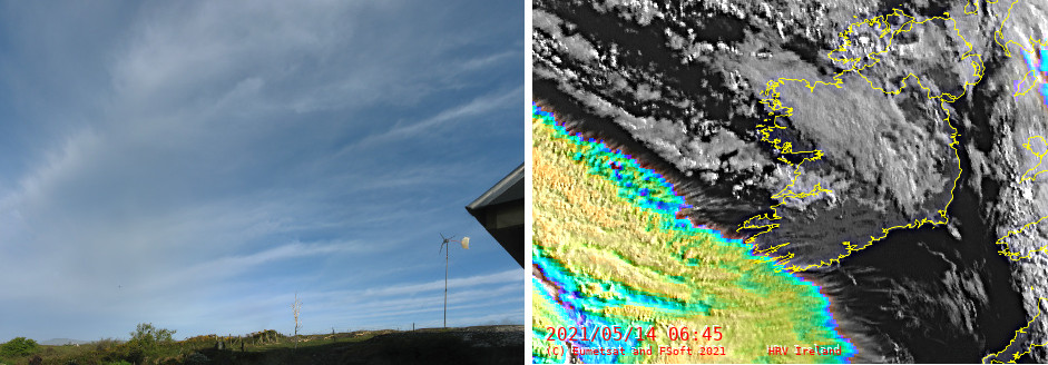
2021-05-14 There were som nice Cloud streets seen today from home. The CirroCumulus in Streets with the High Resolution Visual Image from my Eumetcast Satellite Reception taken at 0645 UTC alongside for reference.
Weather Images received using Eumetcast(C)
I have been using the Python language with the PyTroll library to create images from the weather satellite data I receive here at home for some years now. Python 2.7 is near end of life, so I have moved to Python 3 and the SatPy library which does produce some smashing images. Especially the night ones with the Blackmarble Background. Read on.......
- The North Atlantic Synopsis
This is seen on the Home Page and can be found here also. It is the UK Met Office Synoptic Chart for the North Atlantic and Western Europe overlayed on the Eumetsat Data I receive using Eumetcast but delayed by 2 hours before showing here to comply with the license. There are various products represented by combining various wavelengths to give false colour. The Night images use a Blackmarble background from NASA with city showing up nicely! - Full Globe Images
Here are the Full Globe Images the North Atlantic Images derive from. I find it particularly interesting to see the 0600 and 1800 images which show the transition between day and night, and also show the angle of the earth's tilt. - Other Eumetsat Products
This includes
The daytime High Resolution Visual Images for the British Isles and Ireland.
The Sea Ice Concentration for the Arctic and Antarctic.
The Multi Month Diurnal Barometric Pressure for my location.
The Lightning Sensor Data - a New Project